2009 Himachal Pradesh
Under the shadows of mighty
It had been on my mind now for a long time to explore the
foothills of the great
I would have loved to spend few days or even a week at few
places but I did not have much choice, so the whole trip finished in a breeze
and I still am digesting tons of it.
Planning
The route was already on my mind. The question was only
weather-dependent. In 2007 I had to
trace back 500kms because just before Nako, there was a landslide a day before
I tried to cross it. The rains are a killer in this region. Usually, it drizzles and the mountain pebbles
and stones hold on to the earth. But if it rains, everything comes down. So the big question was timing. Knowing the late arrival of monsoon in
Almost all Maps on
Preparation
My travel checklist was updated and replenished including
First-Aid, Tool kit, clothing, music, Notebook, charging options, Cameras with
lenses, mobile harddisks etc. My Jeep 4x4 Off-roader Maruti Gypsy was standing
for 4-5 months, waiting for better times. I had it fully serviced and driven perhaps 200km before parking it for
so long. I decided not to get is serviced before going on this trip.
A new thing I wanted to experiment this time was to Video-film
the entire journey. So the little Canon IXUS 90IS (640x480pix movie option)
with 16GB CF card (good for 2hrs 20min recording) was prepared and mounted. On
this trip, I worked with three GPS systems. My most reliable Garmin MAP60CS, AMAX 3.5inch MapMyIndia to verify their
claims and my PPC HTC Sedna 6500 with PathAway Pro v5 (Maps with different
resolutions) loaded on it. And, of course, one Jerry-can of 20litre. I was now
all set to go for this trip. I was
driving myself on this trip as well.
The route
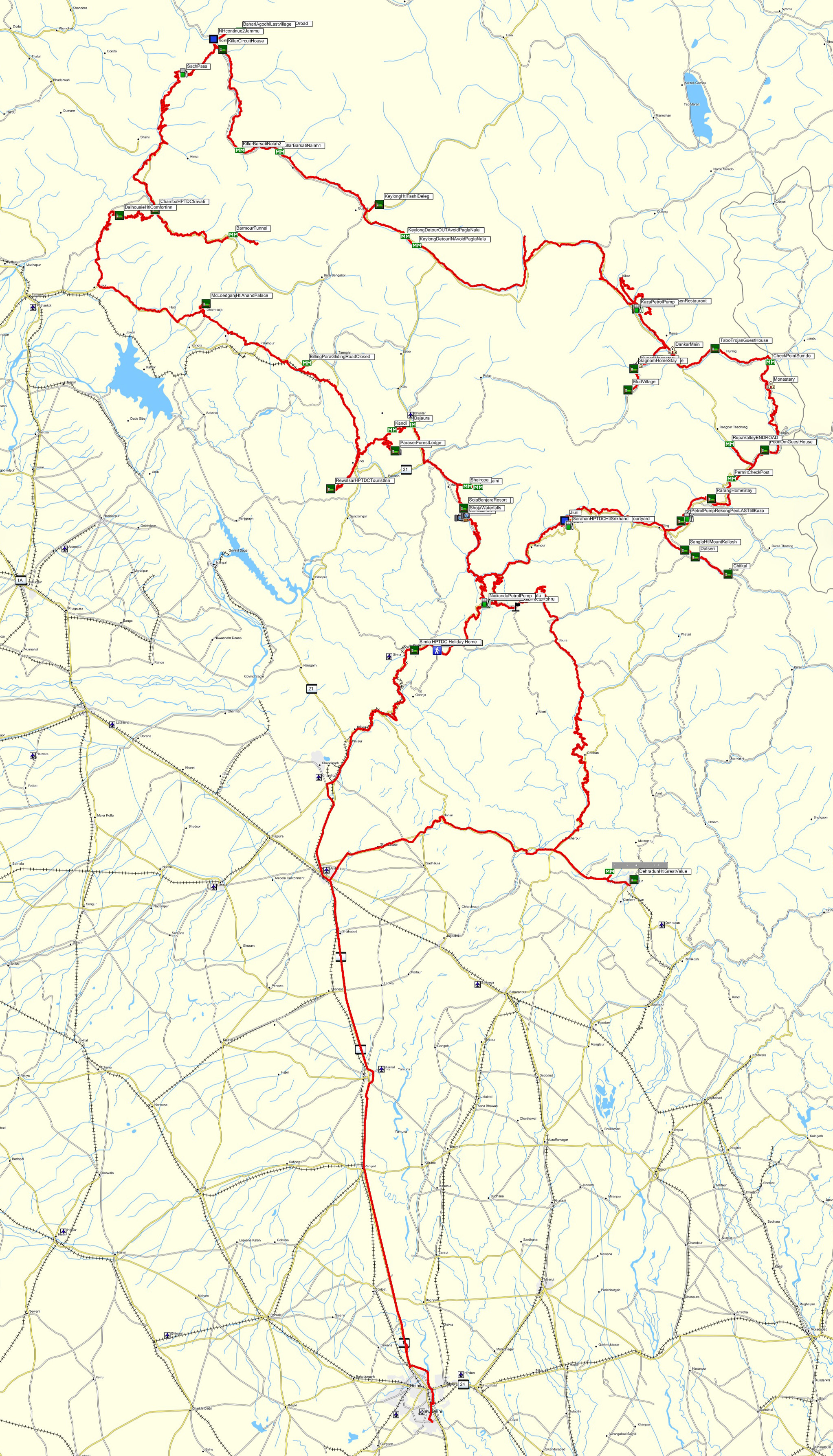
I wanted to cover all the 3 out of 4 main passes in HP (Rohtang
has been done before). So the route was from
The terrain, the roads and
the surroundings
The terrain on this route lies between 500m and 4550m. This is
80% of the route, the rest 20% being
The road Delhi-Shimla is a normal run except for a part after
you leave the main Highway before
The road to Billing para-gliding was closed at the top due to landslide
and we had to come back just few kilometers short of reaching the top. There is a new road coming up joining Comic
to Kaza. We went a bit further but had to return as the road became almost
non-motorable also for 4x4. It should be
ready in few years. From Narkanda to Rohru, there is a short route before
Sungri which goes directly to Rohru. But I avoided that as already the rains
had badly damaged the main road to Rohru via Sungri. I was lucky enough to have completed the
entire journey as soon after I crossed Spiti valley, it was closed due to
landslides and rain and many people were stranded. So much for the planning and a bit of luck !!
Himachal is lush green with beautiful houses not only from
outside but also from inside. People were generally very hospitable and well
off. Its full of apple orchards, many
vegetable gardens and various dry fruits. The surroundings change with the topography. Even before Pooh, the lush
green areas were replaced by typical Ladakhi terrain, full of earth and rocks
and pebbles. This lasts all the way almost till Keylong. The green areas start
again and more or less its green all the way except for the Saach pass stretch
at the higher elevation. I loved the
vastness and the clear skies of Ladakh. One could see for miles as you are
already of such a high plateau. In HP
except for a few places, its all valleys and rivers and beautiful clusters of
old and new wooden or cement houses. This
is a definitive contrast to the higher altitude. But that was also the reason why I went to
HP.
Villages, its people and
living
What really hit me was that many times when we started early
morning, I noticed the Whisky, Beer Shops already open. Good known local brands. No country liquor….
So much for the prosperity. People were
everywhere very friendly, simple and above all smiling at you. Makes a lot of difference. Villages were reasonably clean (could have
been better) and many farmers having cars. But then also after RekongPeo there is no Petrol Pump till Kaza. I saw some
of them buying petrol from local shops. I guess that’s the way it works but then there is no surety of
quality. Most of them have parabolic
dishes for satellite TVs. In winter it must be very occupying. The mobiles are
also floating around and BSNL works everywhere…well almost. My Airtel functioned also but only in the
populated areas of lower end. There is
no Airtel near border till uptill reaching Chamba. Thereafter, most of the time
it worked.
Most of Himachali do well due to apple farms but are also little
educated and wanting to work. That is
easily noticed all over this State. The cities are crowded and dirty, lack of
owning responsibility and civic sense is also noticeable here. But unlike the States in plains, it is
reasonably clean. The life in higher
mountains are still very traditional and mostly Hindus and Buddhists. I found
plenty of
Photographs
Camera Canon 1DS Mark III, Canon L series Lenses 24-105, 100-400,
70-200 and 50. I made it a point to stop very often and take pictures. So I
shot plenty of RAW format in 28 days. Also the filming part was very regular so
I could get a reasonably good collection of the tracks. All RAW images are
Geocoded.
In all, there is enough to cover the trip very well. The sector from
Comments
The trip was not taken as holiday but more like working to
explore Himachal on a fixed program. So
it was a long day from early mornings till late evenings everyday with
check-ins and check-outs. It was a very
demanding trip, both mentally as well as physically, especially because I was
driving myself besides doing everything else. Having said that, I would love to
do it again. Mind you that many places
its extremely moderate accommodation. I
am thankful to both the Travel Agencies for having chosen the right Hotels/Guest
Houses as well as the pleasant accompanying guide who showed remarkable
understanding while I stopped every 10min to shoot -on the entire trip..!! Finally, the mother nature was more or less
dry except for some very heavy showers while on the move.
Finally
I am enclosing here a DataSheet showing following points from
this trip :
Start and Stop timings per Track and distance covered.
Travel Map with covered tracks and various Waypoints marked on it.
Elevation profile per track as also for the entire trip.
Comparison of Elevation profile between Himachal and Ladakh.
Hotels and their suggested ratelist.
© Ajay Narayan
Dated: 14th October 2009, Zürich
www.ajaynarayan.com